The Aerial Photo Latest data set refers to the latest aerials available from state and local government in Florida. The year of the aerials vary by county. Every county is updated at a minimum every 3 years.
Six inch resolution has been the standard resolution since 2016. One foot resolution was the standard between 2005 and 2015.
All counties are flown with digital sensors. Some counties only fly 3-band true color and others add a 4th band for color-infrared. This data set only includes true color aerials.
The Florida Department of Revenue (FDOR) is required to furnish County Property Appraisers high-resolution aerial photos every three years to help with property assessments. The Florida Departments of Transportation and Revenue work together with other state and local governments to set technical standards and share the costs of acquiring these aerial photos.
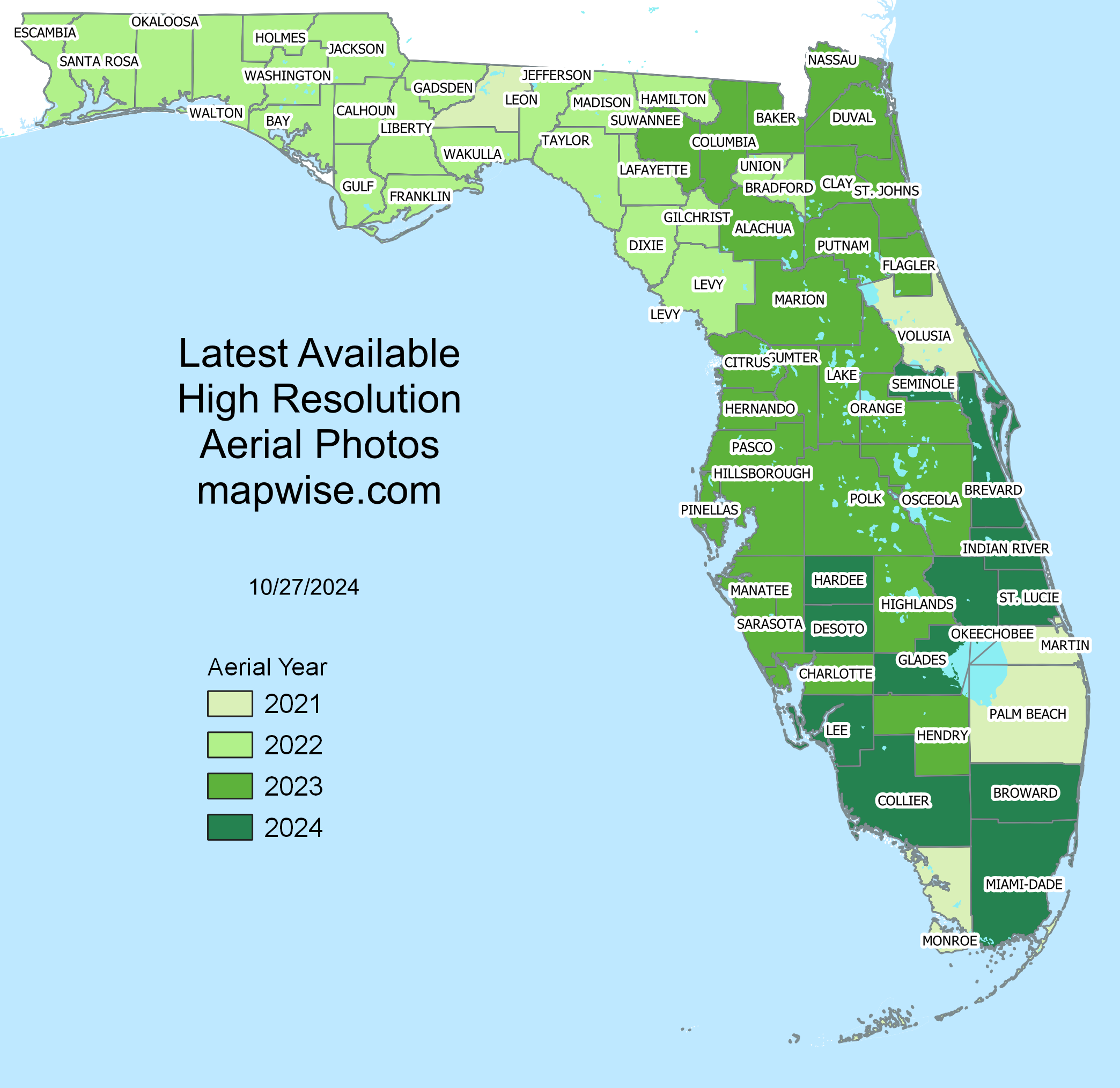
| County | Year | Type | Resolution |
|---|---|---|---|
| Alachua County | 2023 | True Color | 6-inch |
| Baker County | 2023 | True Color | 6-inch |
| Bay County | 2022 | True Color | 6-inch |
| Bradford County | 2022 | True Color | 6-inch |
| Brevard County | 2021 | True Color | 6-inch |
| Broward County | 2021 | True Color | 6-inch |
| Calhoun County | 2022 | True Color | 6-inch |
| Charlotte County | 2023 | True Color | 6-inch |
| Citrus County | 2023 | True Color | 6-inch |
| Clay County | 2023 | True Color | 6-inch |
| Collier County | 2021 | True Color | 6-inch / 2-foot |
| Columbia County | 2023 | True Color | 6-inch |
| Desoto County | 2023 | True Color | 6-inch |
| Dixie County | 2022 | True Color | 6-inch |
| Duval County | 2023 | True Color | 6-inch |
| Escambia County | 2022 | True Color | 6-inch |
| Flagler County | 2023 | True Color | 6-inch |
| Franklin County | 2022 | True Color | 6-inch |
| Gadsden County | 2022 | True Color | 6-inch |
| Gilchrist County | 2022 | True Color | 6-inch |
| Glades County | 2021 | True Color | 6-inch |
| Gulf County | 2022 | True Color | 6-inch |
| Hamilton County | 2022 | True Color | 6-inch |
| Hardee County | 2023 | True Color | 6-inch |
| Hendry County | 2023 | True Color | 6-inch |
| Hernando County | 2023 | True Color | 6-inch |
| Highlands County | 2023 | True Color | 6-inch |
| Hillsborough County | 2023 | True Color | 6-inch |
| Holmes County | 2022 | True Color | 6-inch |
| Indian River County | 2021 | True Color | 6-inch |
| Jackson County | 2022 | True Color | 6-inch |
| Jefferson County | 2022 | True Color | 6-inch |
| Lafayette County | 2022 | True Color | 6-inch |
| Lake County | 2023 | True Color | 6-inch |
| Lee County | 2023 | True Color | 4-inch |
| Leon County | 2021 | True Color | 6-inch |
| Levy County | 2022 | True Color | 6-inch |
| Liberty County | 2022 | True Color | 6-inch |
| Madison County | 2022 | True Color | 6-inch |
| Manatee County | 2022 | True Color | 6-inch |
| Marion County | 2023 | True Color | 6-inch |
| Martin County | 2021 | True Color | 6-inch |
| Miami-Dade County | 2022 | True Color | 3-inch urban / 6-inch |
| Monroe County | 2021 | True Color | 6-inch |
| Nassau County | 2021 | True Color | 6-inch |
| Okaloosa County | 2022 | True Color | 6-inch |
| Okeechobee County | 2021 | True Color | 6-inch |
| Orange County | 2021 | True Color | 3-inch urban / 6-inch rural |
| Osceola County | 2023 | True Color | 3-inch urban / 6-inch rural |
| Palm Beach County | 2021 | True Color | 6-inch urban / 1-foot rural 2017 |
| Pasco County | 2023 | True Color | 6-inch |
| Pinellas County | 2023 | True Color | 6-inch |
| Polk County | 2023 | True Color | 6-inch |
| Putnam County | 2023 | True Color | 6-inch |
| Santa Rosa County | 2022 | True Color | 1-foot |
| Sarasota County | 2023 | True Color | 6-inch |
| Seminole County | 2021 | True Color | 6-inch |
| St Johns County | 2021 | True Color | 6-inch |
| St Lucie County | 2023 | True Color | 6-inch |
| Sumter County | 2023 | True Color | 6-inch |
| Suwannee County | 2022 | True Color | 6-inch |
| Taylor County | 2022 | True Color | 6-inch |
| Union County | 2022 | True Color | 6-inch |
| Volusia County | 2021 | True Color | 6-inch |
| Wakulla County | 2022 | True Color | 6-inch |
| Walton County | 2022 | True Color | 6-inch |
| Washington County | 2022 | True Color | 6-inch |
On-going
Florida Department of Transportation (FDOT), Florida Department of Revenue (FDOR), County Governments
Labins, FDOT
aerial photo, orthophoto, true color
Florida
Varies, approximately 1:4,800
Varies, approximately +/- 5 feet
MrSID
3 bands 8-bit
Varies: Florida State Plane North HARN, Florida State Plane West HARN, Florida State Plane East HARN, etc.
Major tech companies that create aerial maps gather images from local governments across the U.S. to enhance their systems. Many of these companies also contract out to private companies to fly very high resolution aerial photography. This higher-resolution imagery is often used to support "3-D" aerials in dense urban areas. From suburban areas into rural areas, the imagery typically comes from government sources such as these aerials.